")
")
QRA locator & RS map (user manual)
- Details
- Hits: 1773
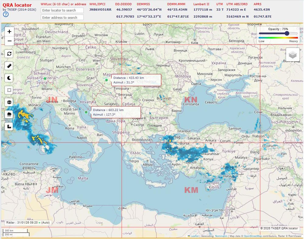 |
This mapping tool is a web-based application developed using JavaScript and PHP. It allows users to manipulate and convert geographic coordinates into various formats used in the world of radiocommunications. |
Update :
Since march 2026, https://rainviewer.com does not allow zoom level greater than 7.
With higher zoom levels, a warning "Zoom level not supported" is displayed.
Key Features:
- QRA Locator (Maidenhead) Calculation: By moving the mouse over the map or entering an address/city, the tool displays the "Locator" (e.g., JN45, JO10, etc.), a coordinate system used by amateur radio operators to locate a station.
- Coordinate Conversion: It instantly provides the position in several formats:
- Latitude/Longitude (Decimal Degrees, DMS).
- UTM coordinates.
- French Lambert II and DFCI coordinates (used specifically by firefighters and for forest fire monitoring).
- APRS compatible format.
- Mapping Tools:
- Distance Ruler: Calculates the distance and azimuth between two points, which is crucial for pointing antennas.
- Maidenhead and DMS grids
- Rain Radar: An overlay layer to visualize real-time precipitation (useful for "Rain Scatter" wave propagation techniques).
- Day/Night Terminator: Displays the "Greyline" on the map.
- Rain scatter ruler : Displays distances/azimut from and to a RS reflection point.
- Map Selection: You can switch between OpenStreetMap, OpenTopoMap, satellite views (ESRI), or terrain maps.
In summary, this is a comprehensive interface for anyone needing to precisely locate a point according to radio standards or plan telecommunication links.
User Manual
Zooming: The map can be zoomed using the mouse wheel or by clicking the ![]() icons at the top left of the screen.
icons at the top left of the screen.
Map Selector: A layer icon ![]() in the top right allows you to choose between different map backgrounds.
in the top right allows you to choose between different map backgrounds.
Data Display: For every search or cursor position, a table at the top of the screen provides the QRA locator, DFCI coordinates (visible for France only), WGS84 geographic coordinates in various formats (decimal, DMS, etc.), Lambert 2 Extended, UTM, and APRS data
![]() Help: Brief help is available by hovering over the help icon
Help: Brief help is available by hovering over the help icon
Searching by QRA Locator (Maidenhead)
The "Enter locator to search" field allows you to display a specific QRA locator. You can enter a 6, 8, or 10-character locator. The search begins as soon as the first 6 valid characters are typed and refines the display after 8 and 10 characters. Example of a precise locator: JN41IW10HD
Searching by Address: The "Enter address to search" field finds the locator for a given address. You can enter "Paris", "Berlin DE", "Rue Saint Jean Lyon", or a zip code like "67190". Press ENTER to start the search.
![]() Reset
Reset
This icon centers the map on the default position (60N, 15E) with a zoom level of 3, showing the entire world map.
![]() Ruler Tool:
Ruler Tool:
Allows measuring distances and azimuths between points. Click on the map to add as many points as needed.
Press ESC to finish or close the tool.
Lines and data boxes remain visible until the tool is triggered again.
To clear and exit, reactivate the tool and click the ![]() icon.
icon.![]() Use the locator or address search fields to place points with high precision.
Use the locator or address search fields to place points with high precision.
![]() Terminator (Greyline)
Terminator (Greyline)
Displays the transition between day and night. A second click hides it. The display updates every minute.
![]() Maidenhead grid
Maidenhead grid
Toggles the WGS84 coordinate grid. The maximum precision shown is 0.1 degrees..
![]() DMS Grid (Degrees Minutes Seconds)
DMS Grid (Degrees Minutes Seconds)
Active ou désactive l'affichage du quadrillage WGS84.
Plus on zoome, plus le quadrillage est précis.
Le quadrillage maximum est de 0,1 degrés.
![]() Rain Radar Layer
Rain Radar Layer
Displays real-time precipitation. This is useful for finding Rain Scatter (RS) reflection points for SHF traffic.
Updates every 5 minutes (radar images are typically released every 10 min).
A window in the top right allows you to adjust the layer opacity and view the intensity color scale.
A status window in the bottom left shows the time of the last image; a flashing green dot indicates the system is working correctly.
![]() RS Ruler Tool
RS Ruler Tool
Displays distances and azimuths from two points toward a rain scatter reflection zone.
- 1st click: Sets the starting point (Green - your QTH).
- 2nd click: Sets the destination point (Red - correspondent's QTH).
- Move the mouse over a reflection zone to see distances and azimuths from both points.
- A 3rd click clears the display, but the tool remains active. Click the [Red Circle] to deactivate.
You must click on the icon to leave the ruler.
![]() You can use the locator entry to place points at specific locations.
You can use the locator entry to place points at specific locations.
Youtube video : https://youtu.be/yuNII8NukY4
![]() The last map center, zoom level, and radar settings are saved and restored during your next visit.
The last map center, zoom level, and radar settings are saved and restored during your next visit.
Feel free to send me your comments, critiques, or encouragement
Patrick TK5EP
Platine universelle LoRa très faible consommation
- Details
- Hits: 1351
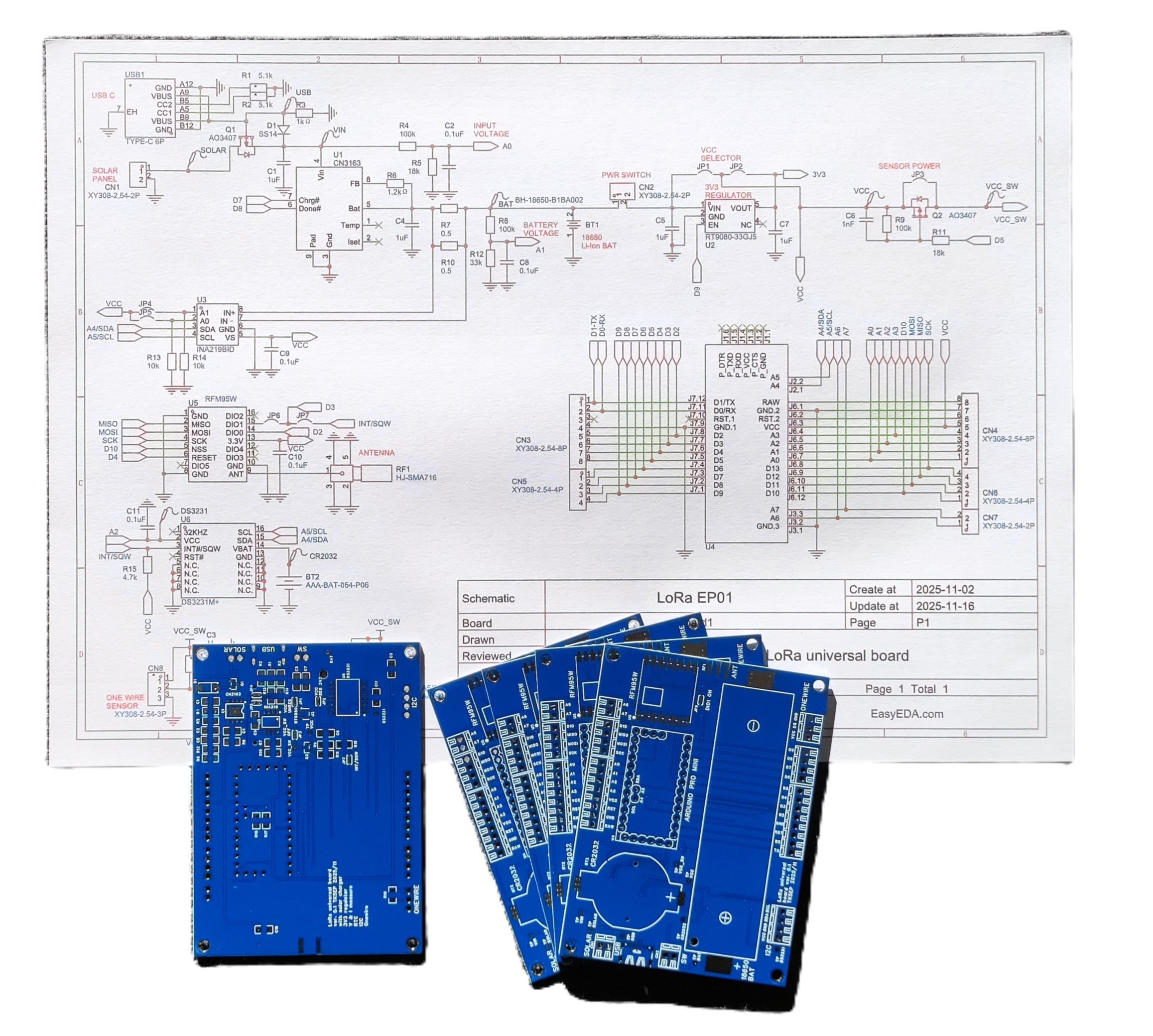 |
Nouveau projet en cours... Conception d'une petite platine destinée à l'expérimentation de solutions IOT LoRa. Modulable au choix, de la version minimaliste à la plus complète avec plusieurs capteurs. |
Printing QSL made easy!
- Details
- Hits: 2131
 |
Managing labels for QSL cards is generally a problem if the data entry software does not include this feature. |
APRS, understanding the telemetry
- Details
- Hits: 9630
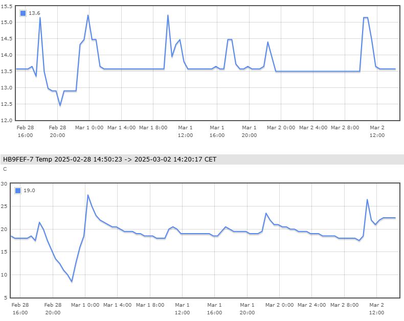 |
The APRS protocol is used to transmit telemetry data, i.e. 5 analog values and 8 binary values (1 or 0). It's not an easy protocol to grasp for the first time. Let's see if we can get to the bottom of it. |
HL-2K amplifier
- Details
- Hits: 7958
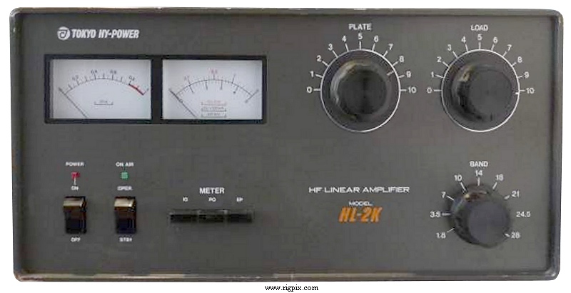 |
The TOKYO HIGH POWER RF amplifier HL-2K is an RF amplifier using two 3-500Z valves that is working on all ham bands, including WARC. It is well built and is a nice looking amplifier, but has some problems and needs some improvements. |
Page 1 of 8
- Kazançlı bir başlangıç yapmak için deneme bonusu sunan bu siteye göz atabilirsiniz.
- Fırsatlarla dolu deneme bonusu veren siteler arasında öne çıkan bir seçenek burada.
- Yeni üyeler için özel bonus veren siteler, avantajlı teklifleriyle dikkat çekiyor.
- Kullanıcı memnuniyetine odaklanan bonus veren siteler, eşsiz fırsatlar sunuyor.
- Güvenilir bir deneyim için deneme bonusu veren siteler, kazanç kapınızı aralıyor.
- Hızlı kazanç fırsatı sağlayan deneme bonusu seçeneklerini keşfedin.
- Avantajlı teklifleriyle deneme bonusu veren siteler, yüksek kazanç imkanı sunuyor.


